
Magnitude and intensity: why one earthquake feels different from place to place
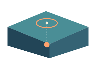
Magnitude describes the size of an earthquake at its source. Intensity describes its effects at a particular location. Here is how to read both correctly.
Read the storyUnderstand earthquakes, volcanoes and the data behind them. Clear explanations, practical guides and links to original sources.
Magnitude describes the size of an earthquake at its source. Intensity describes its effects at a particular location. Here is how to read both correctly.
Read the storyA map marker tells only part of the story. The focus is underground, the rupture covers an area, and distance from the epicentre alone cannot establish safety.
Read the storyAn earthquake map presents selected source records. Learn what the 24-hour window, revisions, filters and missing events mean before drawing conclusions.
Read the storyA USGS ground alert level and an aviation colour code answer different questions. One coloured symbol cannot replace the notice or a local hazard map.
Read the storyEarly warning detects an earthquake that has already started. A forecast estimates probabilities. Reliable precise prediction of a particular earthquake is not available.
Read the storyStart with actions you can take today: secure furniture, choose cover, agree on contacts and practice the plan together.
Read the storyLook beyond the headline: check the issuing center, publication time, named stretch of coast and instructions from local authorities.
Read the storyBuilt-in learning material can support preparation without a connection. Cached earthquake records remain an earlier snapshot, even when they look familiar.
Read the storyA useful kit fits the people who need it, stays accessible and gets checked regularly. Start with water, personal needs and your family plan.
Read the storyStart with one question, test an explanation with a model and identify what the model simplifies. Connect scientific terms to observations.
Read the storyNo stories match your search.