An earthquake is described as 40 km from a city, but its depth is listed as 100 km. Where did it actually happen, and how close was it to someone in that city? A useful answer requires three dimensions: the starting point inside the Earth, its projection onto the surface and the distance from a chosen place.
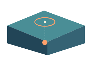
The focus is underground; the epicentre is at the surface
The hypocentre, also called the focus, is where an earthquake rupture starts. The epicentre is the point at the surface directly above it. Depth refers to the hypocentre. Saying that an epicentre is 20 km deep combines two different concepts: the focus is 20 km deep, while the epicentre has a surface latitude and longitude.
A large earthquake involves slip over an extended part of a fault. A marker does not show that entire area and need not coincide with the strongest effects. A point is convenient in an educational diagram, but real analysis also considers rupture geometry. Even an accurately positioned marker cannot turn an earthquake into a process confined to one point.
Which distance are you looking at?
Surface distance to the epicentre differs from distance to the underground focus. Distance to the nearest part of a rupture is another quantity again. In the app, distance from a selected location to the event coordinates helps you navigate the map. It is neither a driving route nor a calculation of the path followed by a seismic wave.
For a simple thought experiment, use a flat cross-section with an epicentre 30 km away horizontally and a focus 40 km deep. The straight line to the focus is the hypotenuse, measuring 50 km. This is a geometry example, not a wave-propagation model for a heterogeneous Earth. It shows why depth cannot simply be ignored or added to the map distance.
Why depth estimates change
Depth is often less well constrained than the epicentre's position. Available wave phases and the distribution of stations limit its precision. When the data are inadequate, the source may assign a fixed depth, such as 10 km. Repeated round values do not by themselves prove identical sources or a faulty catalogue; the details of the location solution matter.
The reference surface matters too. USGS specifies the WGS84 geoid, while other contributing networks may use different reference levels. Zero or slightly negative depth therefore calls for checking metadata and uncertainty, rather than imagining an earthquake in the air. Extra decimal places on a screen also do not guarantee that an estimate is accurate to that many places.
A city name is a geographic reference
USGS builds automated location descriptions using a database of populated places and may use a regional name when no suitable city is available. The label makes an event easier to place geographically. It does not define the affected area. An event north of a city need not be within its limits, and that city need not have experienced the strongest shaking.
Compare coordinates using the same reference location. Switching from your home region to a travel destination will naturally change the displayed distance without changing the earthquake's position. The app supports several manually saved regions. Give them clear names and check the active region and the choice of kilometres or miles before comparing event distances.
Depth provides context, not a complete shaking assessment
Other things being equal, shaking generally weakens with increasing distance from the source; greater depth increases that distance for places directly above the focus. Actual intensity also depends on the size and character of the rupture, the materials waves travel through and local ground conditions. One depth value cannot define a universal safe radius.
Read magnitude, depth and distance together, then examine available intensity information and the official report. At the coast, also follow the relevant warning services. Strong or long shaking or unusual ocean behaviour can be a natural tsunami warning: follow local evacuation guidance without waiting to calculate your distance from the earthquake in an app.
FAQ
Is shaking always stronger closer to the epicentre?
It is a useful general expectation, but not a rule for every location. Rupture extent, its direction of development and local ground conditions affect the pattern. Use location-specific intensity estimates for the area you need.
Why do several events have a depth of exactly 10 km?
When observations are insufficient, a source sometimes assigns a fixed depth. A value of 10 km can be such an estimate, but it can also be a measured result. The official location details help distinguish the cases.
Sources
- USGS — Earthquake Hazards Program Glossary
- USGS — Determining the Depth of an Earthquake
- USGS — Why Do So Many Earthquakes Occur at a Depth of 10km?
- USGS — What Reference Datum Is Used for Earthquake Depths?
- USGS — How Do You Determine the Place Name for an Earthquake?
- USGS — At What Depth Do Earthquakes Occur? What Is the Significance of the Depth?
- NOAA/NWS — Understanding Tsunami Alerts
This is educational information. For emergency decisions, follow local authorities and official warnings.